[OSM-talk] [OSM-legal-talk] Are we strict enough with imports ?
http://lists.openstreetmap.org/pipermail/talk/2010-February/048085.html
ハイチ震災マッピングは例外的だけど、ハイチの場合、古いCIAトレースデータやインポートデータと最新のgeo-eye画像がご対面した時は、手がつけられない時が多かった。このあたり。
http://www.openstreetmap.org/?lat=18.2391&lon=-72.54&zoom=14&layers=B000FTF
2010年5月18日火曜日
2009年12月18日金曜日
[OSM-talk] Contribution graph
[OSM-talk] Contribution graph
http://lists.openstreetmap.org/pipermail/talk/2009-December/045983.html
"It reveals that 95% of the way data is contributed by just 10% of the contributor base. In fact 50% of way data has been contributed by just 31 user accounts although the first few of these are major imports, such as TIGER (32%), AND (2%) and Coastlines."
 単純に"way"としてひとくくりでデータ量としてパーセント化されればこうなりますが、別な視点で世界中では様々な"way"や"マッピング作業"があるわけでその「質的な貢献度の解析」も必要と考えます。
http://lists.openstreetmap.org/pipermail/talk/2009-December/045983.html
"It reveals that 95% of the way data is contributed by just 10% of the contributor base. In fact 50% of way data has been contributed by just 31 user accounts although the first few of these are major imports, such as TIGER (32%), AND (2%) and Coastlines."
単純に"way"としてひとくくりでデータ量としてパーセント化されればこうなりますが、別な視点で世界中では様々な"way"や"マッピング作業"があるわけでその「質的な貢献度の解析」も必要と考えます。
2009年9月7日月曜日
"OSM Cheat Sheet"OSMタグ一覧
"OSM Cheat Sheet"いいですね。私はOSM編集する時、Ja:Map Features
をA4サイズに印刷、綴じ込みしたものを使っていますが、keyや値が多いので種類の違うタグやタグ全体を調べるのにやや時間がかかります。このOSM Cheat SheetではOSMタグが一枚にまとめられているため、タグ全体が把握しやすく使いやすいと思います。時間ができたらOSM Cheat Sheetの日本版作ってみようかと思います。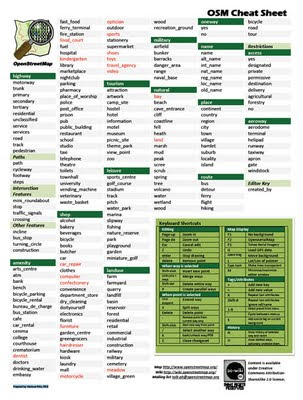 Cheat sheet
http://wiki.openstreetmap.org/wiki/Cheat_sheet
[OSM-talk] Cheat Sheet
http://www.mail-archive.com/talk@openstreetmap.org/msg16787.html
をA4サイズに印刷、綴じ込みしたものを使っていますが、keyや値が多いので種類の違うタグやタグ全体を調べるのにやや時間がかかります。このOSM Cheat SheetではOSMタグが一枚にまとめられているため、タグ全体が把握しやすく使いやすいと思います。時間ができたらOSM Cheat Sheetの日本版作ってみようかと思います。
Cheat sheethttp://wiki.openstreetmap.org/wiki/Cheat_sheet
[OSM-talk] Cheat Sheet
http://www.mail-archive.com/talk@openstreetmap.org/msg16787.html
2009年5月21日木曜日
[OSM-talk] Potlatch 1.0
OSMエディタPotlatch のVer1.0が出ました!Potlatchでoffline編集が可能になりました。他の機能変更もあります。

[OSM-talk] Potlatch 1.0
Hi all,
It's been an important 24 hours for the webmapping world. At last -and after many months of expectation - UK cycle charity Sustrans
released their new online slippy map. Oh yeah, and some irritating USoutfit did some data API or something.
But never mind any of that, because it's also Potlatch's second birthday!
And that means: it's time for Potlatch 1.0.
What's new? Online help. Offline editing. Conflict management.
A new way of showing junction nodes. Better changeset handling. And some other stuff.Bugs and comments? Trac, of course, but there's also a new potlatch-dev mailing list - both for current Potlatch and exciting future stuff.
Subscribe: http://lists.openstreetmap.org/pipermail/potlatch-dev/
Enjoy!
cheers
Richard


[OSM-talk] Potlatch 1.0
Hi all,
It's been an important 24 hours for the webmapping world. At last -and after many months of expectation - UK cycle charity Sustrans
released their new online slippy map. Oh yeah, and some irritating USoutfit did some data API or something.
But never mind any of that, because it's also Potlatch's second birthday!
And that means: it's time for Potlatch 1.0.
What's new? Online help. Offline editing. Conflict management.
A new way of showing junction nodes. Better changeset handling. And some other stuff.Bugs and comments? Trac, of course, but there's also a new potlatch-dev mailing list - both for current Potlatch and exciting future stuff.
Subscribe: http://lists.openstreetmap.org/pipermail/potlatch-dev/
Enjoy!
cheers
Richard
2009年5月18日月曜日
Satellite for OSM
以前”夢のOSM衛星”について書きましたがOSM-talkでも話題が出ています。[OSM-talk] Satellite for OSM
でもFrederikさんに
「Not if you plan to let it make photos that are of better resolution thanLandsat though!」
とキッチリ指摘されてます。衛星を上げることよりもランドサット以上の写真データを得るためのフロー、コストを考えないといけません。
でもFrederikさんに
「Not if you plan to let it make photos that are of better resolution thanLandsat though!」
とキッチリ指摘されてます。衛星を上げることよりもランドサット以上の写真データを得るためのフロー、コストを考えないといけません。
2009年5月2日土曜日
The OpenView Project
OSM-talkで見かけたThe OpenView Project、面白いです。
・・・The idea of creating interactive panoramas still stuck with me. I loved what Google had done, but the more I used it, the more I realized the place was less important than the people. If you look at any of the Google Street View sightseeing sites, you will see one common theme - people. Unfortunately in our modern society, streets aren’t the dominant place where people go. People go to the beach, they go to the mall, they go to the park, they go to concerts, basically everywhere Google can’t drive their Google Street View Van. This idea still stuck with me, and if there’s anything I’ve learned in the 27 years I’ve been alive, it’s that being part of something is far more exciting than just being a spectator.・・・
・・・The idea of creating interactive panoramas still stuck with me. I loved what Google had done, but the more I used it, the more I realized the place was less important than the people. If you look at any of the Google Street View sightseeing sites, you will see one common theme - people. Unfortunately in our modern society, streets aren’t the dominant place where people go. People go to the beach, they go to the mall, they go to the park, they go to concerts, basically everywhere Google can’t drive their Google Street View Van. This idea still stuck with me, and if there’s anything I’ve learned in the 27 years I’ve been alive, it’s that being part of something is far more exciting than just being a spectator.・・・
2009年5月1日金曜日
[OSM-dev] What is OSM and what isn't?
見慣れたOSMトップページにGet directionsタブが付いてルート検索ができます。
[OSM-dev] Cloudmade routing for OSM rails_port site.
 Cloudmade routingをOSMサイトで使うことにJochen Topfさんは疑問を投げかけています。
[OSM-dev] What is OSM and what isn't?
[OSM-talk] [OSM-dev] What is OSM and what isn't?
私はAndy Allanさんの考えに近いような。
とは言ってもconsumerよりまだcontributorでいるでしょう。好きだし。
[OSM-dev] Cloudmade routing for OSM rails_port site.
 Cloudmade routingをOSMサイトで使うことにJochen Topfさんは疑問を投げかけています。
[OSM-dev] What is OSM and what isn't?
[OSM-talk] [OSM-dev] What is OSM and what isn't?
私はAndy Allanさんの考えに近いような。
とは言ってもconsumerよりまだcontributorでいるでしょう。好きだし。
2009年4月25日土曜日
[OSM-talk] Will Yahoo! outsource its Maps?
http://lists.openstreetmap.org/pipermail/talk/2009-April/036290.html
>We all know that Yahoo! is in financial trouble and maintaining Yahoo! Maps is definitely not cheap.
http://www.geowebguru.com/news/132-yahoo-to-sell-yahoo-maps
>We all know that Yahoo! is in financial trouble and maintaining Yahoo! Maps is definitely not cheap.
http://www.geowebguru.com/news/132-yahoo-to-sell-yahoo-maps
2009年2月27日金曜日
StreetView from norc with OpenStreetMap
オープンストリートマップにNorcストリートビューが載ってます。
Bucharestの街はGmapが詳細地図でカバーしておらず、OSM地図とNorcストリートビューがペアリングしています。


 http://wiki.openstreetmap.org/wiki/Featured_image_proposals#StreetView_from_norc_with_OpenStreetMap
http://www.norc.ro/
http://www.norc.ro/norc.aspx
[OSM-talk] permission to derive from Romanian streetview-alike?
StreetView from norc with OpenStreetMap
Bucharestの街はGmapが詳細地図でカバーしておらず、OSM地図とNorcストリートビューがペアリングしています。


 http://wiki.openstreetmap.org/wiki/Featured_image_proposals#StreetView_from_norc_with_OpenStreetMap
http://www.norc.ro/
http://www.norc.ro/norc.aspx
[OSM-talk] permission to derive from Romanian streetview-alike?
StreetView from norc with OpenStreetMap
2009年1月25日日曜日
[OSM-talk] When is a bridge not a bridge?
bridgeタグについての論議です。私も橋の橋梁部分にポイントを落とす際に悩む事は度々あります。何度か都市部の大きな橋で橋の境があいまいになりました。ここではLayerタグを使っての表現についても議論されていますが、Layerタグによる表現手法は便利ですが、使いすぎると整合性が難しくなると思います。
80n to talk
David
Was there a specific purpose you had in mind that needs to distinguish between the main span of a bridge and it's ramps, or were you just exploring the level of consistency in current tagging practices?
I wonder if we are approaching this problem from the right direction.
There are currently about 250,000 ways that are tagged bridge=yes. Since there's no generally agreed definition of the extent of a bridge every user will have used a different assumption and their own judgement.
Perhaps we should keep the vague and approximate definition that the bridge tag provides, and instead propose extra tags that more precisely define the lesser characteristics of a bridge. The bridge tag as it currently exists, for all its vagueness, is easy to use and effective.
For more precision we could consider additional tags that precisely define the individual parts of a bridge. The addition of a bridge_ramp tag, for example, could be used to indicate whether or not a bridge includes or excludes the ramps.
bridge=yes, bridge_ramp=includedexcluded
For those that want to define the extent of the ramps specifically then a separate way would be required for each ramp and for the main span, perhaps like this:
bridge=yes, bridge_ramp=yesbridge=yes, main_span=yesbridge=yes, bridge_ramp=yes
However, I'm not sure such an elaborate scheme would catch on much unless there's a real benefit in tagging bridges to a greater level of detail. That's why I wondered whether you have a specific reason for wanting to tag bridges with more precision.
80n
80n to talk
David
Was there a specific purpose you had in mind that needs to distinguish between the main span of a bridge and it's ramps, or were you just exploring the level of consistency in current tagging practices?
I wonder if we are approaching this problem from the right direction.
There are currently about 250,000 ways that are tagged bridge=yes. Since there's no generally agreed definition of the extent of a bridge every user will have used a different assumption and their own judgement.
Perhaps we should keep the vague and approximate definition that the bridge tag provides, and instead propose extra tags that more precisely define the lesser characteristics of a bridge. The bridge tag as it currently exists, for all its vagueness, is easy to use and effective.
For more precision we could consider additional tags that precisely define the individual parts of a bridge. The addition of a bridge_ramp tag, for example, could be used to indicate whether or not a bridge includes or excludes the ramps.
bridge=yes, bridge_ramp=includedexcluded
For those that want to define the extent of the ramps specifically then a separate way would be required for each ramp and for the main span, perhaps like this:
bridge=yes, bridge_ramp=yesbridge=yes, main_span=yesbridge=yes, bridge_ramp=yes
However, I'm not sure such an elaborate scheme would catch on much unless there's a real benefit in tagging bridges to a greater level of detail. That's why I wondered whether you have a specific reason for wanting to tag bridges with more precision.
80n
2009年1月20日火曜日
[OSM-talk] Potlatch version 8 million?・・・素晴らしい!
Peter MillerさんがOSM-talkで良いビデオを紹介してくれました。
こんなPotlatch!?未来形、最高!・・・と同時にマッピング、データ取得のフィールドワーク装備も進化が望まれます。GPSはもちろんレベル計測や汎用3Dスキャナーがより身近なものになって欲しいです。
[OSM-talk] Potlatch version 8 million?
So should the Crysys engine be the benchmark for our new editor. Ok,
so probably not, but I guess we are going to see people pouring OSM
data into these gaming engines soon and then manipulating it. I love
the ways they canmodify the environment in real time by pull roads
around and filling in the ground.・・・・・
Peter Miller
GDC 2007: Crysis CryEngine2 Level Editor Demo Pt.2
こんなPotlatch!?未来形、最高!・・・と同時にマッピング、データ取得のフィールドワーク装備も進化が望まれます。GPSはもちろんレベル計測や汎用3Dスキャナーがより身近なものになって欲しいです。
[OSM-talk] Potlatch version 8 million?
So should the Crysys engine be the benchmark for our new editor. Ok,
so probably not, but I guess we are going to see people pouring OSM
data into these gaming engines soon and then manipulating it. I love
the ways they canmodify the environment in real time by pull roads
around and filling in the ground.・・・・・
Peter Miller
GDC 2007: Crysis CryEngine2 Level Editor Demo Pt.2
2008年12月22日月曜日
JOSM WMS Plugin


OSM-talkにWMS Pluginの話題が出ていたので久しぶりにJOSMをアップデート(Ver.1150)してWMS Pluginを使ってみました。
プラグイン一覧を見てみると、Yahoo Aerial を表示させるのに必要だったywms(A WMS server for Yahoo imageery based on Firefox)がリストに見あたらず、wmspluginのみしか見えません。
この設定でwmspluginを使うと「Open Aerial Map」が使えるようになっていました。
以前ywmsとFirefox3の組み合わせではうまくYahoo Aerial が表示されない問題にぶつかりましたが今回はFirefox3でも「Open Aerial Map」が問題なく使えます。
2008年12月16日火曜日
[OSM-talk] Google Maps - OSM comparison

[OSM-talk] Google Maps - OSM comparison
世界200以上の都市についてOSMとGoogle Mapsの比較ができます。
これの日本国内都市版が欲しいです!
http://lamp2.fhstp.ac.at/~lbz/beispiele/ws2008/capitals/index.php
2008年12月3日水曜日
[OSM-talk] Map Features
[OSM-talk] Map Features
> Since at least a few are using smoothness, I don't see any problem to put
> it
> on map features, and let people who want, use it.
Are you *seriously* suggesting that we put every tag used by "at least a few" on the main map features page?
According to Tagwatch - there are over 4300 keys in use in Europe alone, each potentially with multiple values. It's just not practical to display every one of them.
Perhaps Map Features should be for the main core tags only (for newbies mainly - the basics of how to get their road/feature displayed). Perhaps we should limit it to the things we consider important enough to render on the main renderers - and we can have other pages for more specialist tagging - e.g. the properties of these ways.
Richard Bullock
> Since at least a few are using smoothness, I don't see any problem to put
> it
> on map features, and let people who want, use it.
Are you *seriously* suggesting that we put every tag used by "at least a few" on the main map features page?
According to Tagwatch - there are over 4300 keys in use in Europe alone, each potentially with multiple values. It's just not practical to display every one of them.
Perhaps Map Features should be for the main core tags only (for newbies mainly - the basics of how to get their road/feature displayed). Perhaps we should limit it to the things we consider important enough to render on the main renderers - and we can have other pages for more specialist tagging - e.g. the properties of these ways.
Richard Bullock
2008年12月1日月曜日
[OSM-talk] Edit war on the wiki "map features"
Frederik Ramm wrote:
> Most of all since we're growing exponentially and even if we had 90% of
> mappers agree on something today, in two or three months those 90% would
> perhaps only form 30% of the community...
This is actually an argument _for_ Map_Features and some sort of meritocracy, not against.
In order to know which sort of tagging schemes work well and which don't, the biggest thing you need is experience. If you don't have that, and if you aren't given guidance, you are likely to tag in dumb ways.
And, as we are expanding so fast, the experienced will always be outnumbered by the inexperienced. Which means that, without guidance, most tagging will be not as good as it could be.
Having experienced people in leadership, and actually doing some leading and making decisions, is something that most groups consider an asset, not something to be avoided. I continue to be amazed that OpenStreetMap is so allergic to it - at least in the area of tagging.
No-one is suggesting forbidding people from tagging however they like.
But "you can tag any way you like" is not the same as "all taggingschemes are equally sensible"or "we should make data consumers andrenderers support six different ways of doingeverything if they want torender the whole world".
(Exactly how one would get to the stage of having appropriately-chosen decision-makers is a different question, of course. But route is not the same thing as destination.)
Gervase Markham
> Most of all since we're growing exponentially and even if we had 90% of
> mappers agree on something today, in two or three months those 90% would
> perhaps only form 30% of the community...
This is actually an argument _for_ Map_Features and some sort of meritocracy, not against.
In order to know which sort of tagging schemes work well and which don't, the biggest thing you need is experience. If you don't have that, and if you aren't given guidance, you are likely to tag in dumb ways.
And, as we are expanding so fast, the experienced will always be outnumbered by the inexperienced. Which means that, without guidance, most tagging will be not as good as it could be.
Having experienced people in leadership, and actually doing some leading and making decisions, is something that most groups consider an asset, not something to be avoided. I continue to be amazed that OpenStreetMap is so allergic to it - at least in the area of tagging.
No-one is suggesting forbidding people from tagging however they like.
But "you can tag any way you like" is not the same as "all taggingschemes are equally sensible"or "we should make data consumers andrenderers support six different ways of doingeverything if they want torender the whole world".
(Exactly how one would get to the stage of having appropriately-chosen decision-makers is a different question, of course. But route is not the same thing as destination.)
Gervase Markham
2008年11月19日水曜日
[OSM-talk] Using images as a backdrop for editing OSM data
[OSM-talk] Using images as a backdrop for editing OSM data

「MapWarper」の使い方がやっとわかってきました・・が、まだJOSMへ載せるステップが?

「MapWarper」の使い方がやっとわかってきました・・が、まだJOSMへ載せるステップが?
2008年11月4日火曜日
[OSM-talk] A project for winter - Building heights
[OSM-talk] A project for winter - Building heights
建物高さtagを使った3Dどうします?
こちらは地形3D
OpenStreetMap 3D - Short Video
http://igorbrejc.net/openstreetmap/openstreetmap-in-3d
建物高さtagを使った3Dどうします?
こちらは地形3D
OpenStreetMap 3D - Short Video
http://igorbrejc.net/openstreetmap/openstreetmap-in-3d
2008年9月16日火曜日
[OSM-talk] Ito World offers expanded Coverage for OSM Mapper to include Africa, the Middle East, Asia, Australasia, South America and Canada
OSMの入力時期を地図上で色別表現する。
9月2日 [OSM-talk] Ito World offers expanded Coverage for OSM Mapper to include Africa, the Middle East, Asia, Australasia, South America and Canada
http://itoworld.blogspot.com/2008/08/expanded-coverage-for-osm-mapper.html
http://itoworld.blogspot.com/2008/07/new-osm-mapper-for-openstreetmap.html
9月2日 [OSM-talk] Ito World offers expanded Coverage for OSM Mapper to include Africa, the Middle East, Asia, Australasia, South America and Canada
http://itoworld.blogspot.com/2008/08/expanded-coverage-for-osm-mapper.html
http://itoworld.blogspot.com/2008/07/new-osm-mapper-for-openstreetmap.html
[OSM-talk] OpenStreetMap routing service
OSMでのルート検索について
9月7日 [OSM-talk] OpenStreetMap routing service
http://tile.openstreetmap.nl/~lambertus/routing-world/
9月7日 [OSM-talk] OpenStreetMap routing service
http://tile.openstreetmap.nl/~lambertus/routing-world/
[OSM-talk] [GSoC] JOSM Plugins
OSM-talkでの過去の話題をもう一度探すのに一苦労するのでOSM-talk備忘録としてこちらにアップします。
9月5日 GPSログを直接JOSMに読み込むプラグインのお話。
[OSM-talk] [GSoC] JOSM Plugins
http://wiki.openstreetmap.org/index.php/User:Subhodip/GSoC_Doc
9月5日 GPSログを直接JOSMに読み込むプラグインのお話。
[OSM-talk] [GSoC] JOSM Plugins
http://wiki.openstreetmap.org/index.php/User:Subhodip/GSoC_Doc
登録:
投稿 (Atom)
週刊OSMを見てみよう!
週刊OSM( weeklyOSM) は、 OpenStreetMapに関する世界中の出来事トピックについて毎週ボランティアメンバーによって編集と多言語翻訳が行われ、公開されています。 OSMに関して、コミュニティやOSM編集、タグ付け、 データベース、 技術開発、 企業団体、...

-
1.郡山市のOSMマッピング 福島県郡山市のOSMマッピングは2008年頃スタートして現在に至っています。 それでもまだまだマッピングが不十分な箇所があります。 郡山市OSMのベースマップの品質を均一にし、充実させるためにタスキングマネージャーを使ってマピングしています。編集エリ...
-
週刊OSM( weeklyOSM) は、 OpenStreetMapに関する世界中の出来事トピックについて毎週ボランティアメンバーによって編集と多言語翻訳が行われ、公開されています。 OSMに関して、コミュニティやOSM編集、タグ付け、 データベース、 技術開発、 企業団体、...
-
 OpenStreetMap入門つぶやきビデオシリーズ作ってみました。 海外のOSMチュートリアルビデオは数多くありますが日本向けは 少なかったので日本の多くの方がOpenStreetMapオープンストリートマップに親しんでいただけるようビデオにまとめました。 内容は OSMユーザ...

